
BIG EARTH DATA ANALYSIS
Semantic Earth Observation with our Data Cube
Sentinel-2 Semantic Earth Observation Data and Information Cube for Austria is the world’s first prototype of a semantic EO data cube covering all of Austria and includes all available Sentinel-2 images since Sentinel-2A was launched in 2015.
We offer new and innovative functions for semantic, content-based image search and image analysis of all captured Sentinel-2 images in user-defined regions and time intervals without the need of special software and without downloading satellite data – available in the web-browser!
Satellite data made easy
The massive volumes of data provided by the Copernicus programme need to be processed to higher-level products to unlock their full potential. The data we are using for our Data Cube is provided by Sentinel-2.
The Data Cube delivers a system making Copernicus data available to the broad public. Our Data Cube stores the data in a gridded multi-dimensional database capable of providing time-series of highly standardized and harmonized radiometrically and geometrically corrected satellite data. These data are made available through a graphical user-friendly and standardized interface (GUI) for novel users and a dedicated application programming interface (API) for advance users. The benefits include cloud-based storage and processing, so users can directly download the ready-to-use data for their specific region of interest, without performing the time-consuming pre-processing steps. In addition, the scalable service allows for integration of user relevant geodata (e.g. digital elevation model, leaf area index, open street maps).
We have the know-how where to retrieve the data, the programming experience to implement the algorithms, large amounts of storage space, and have the computing power.

The data cubes stores images and image derived products for fast querying
1: Optical satellite image and associated fully automatic data-derived information layers.
2: Semantic EO data cube: Manages multi-temporal images and image-derived information with low technical access barriers and high scalability
3: Web-based inference engine: Semantic spatiotemporal queries in user-defined AOIs using a semantic querying language interpreting human-like queries / thematic descriptions
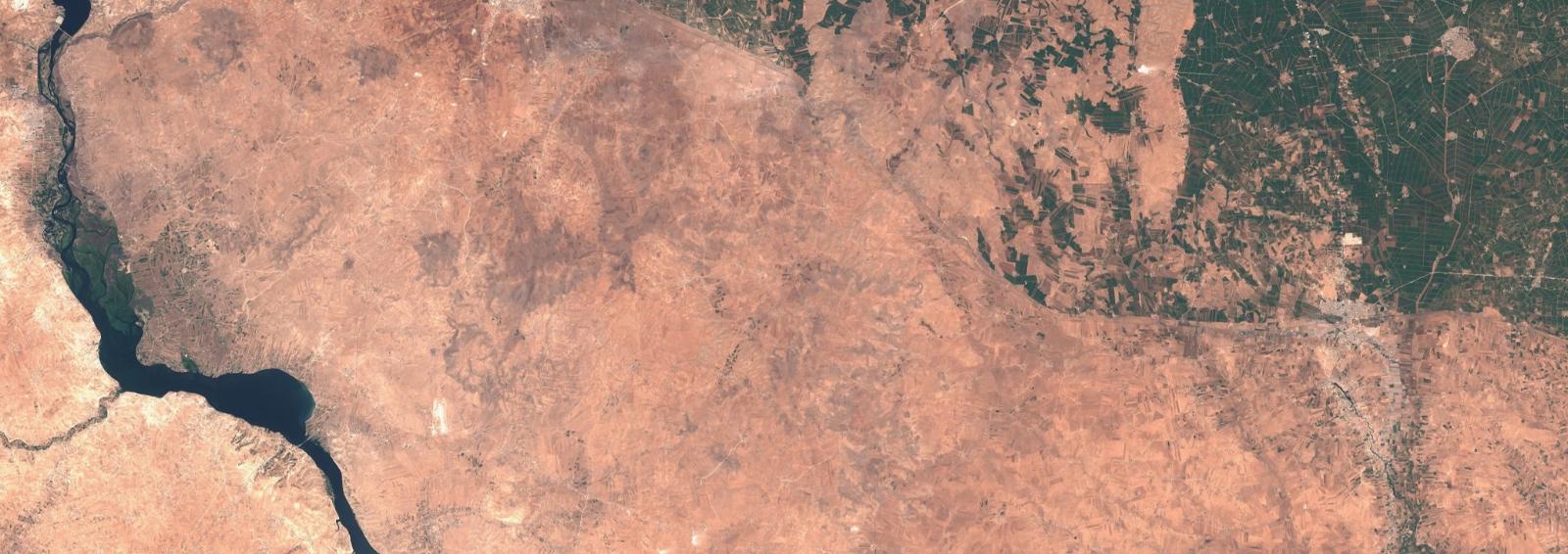
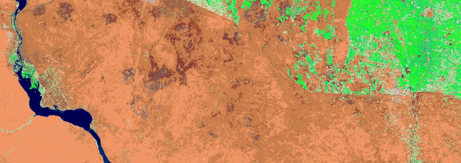
Sentinel-2 image (left) – Sentinel-2 image, semantically enriched (right)
Background knowledge: The Sentinel fleet
The European Copernicus programme is operating and expanding an extensive constellation of EO satellites carrying a range of different sensors. In total six different Sentinels are working or ar planned to scan the earth. The current seven operation Sentinels collect 15 TB of raw data daily, thus an extensive archive of EO data needs to be maintained.
- The Sentinel-1 satellites fly in an approximately 700 km high polar orbit, scanning the Earth in swaths of 80 to 400 km. Additional a C-band SAR (Synthetic Aperture Radar) with a wavelength of 6 centimeters is used.
- Sentinel-2 also consists of two satellites in the same orbit. Sentinel-2 is intended to provide multispectral earth observation data as a continuation of Landsat or SPOT. Images will be acquired at spatial resolutions of 10 or 20 m per pixel in 10 spectral channels in the wavelength range from 443 to 2190 nm. In addition, there are three narrow-band spectral channels with 60 m spatial resolution for measuring atmospheric properties.
- Sentinel-3 is designed to measure land and ocean colors as a continuation of Envisat’s Meris instrument, land and sea temperature as a continuation of AATSR, and sea surface and ice topography as a continuation of Envisat’s altimeters. There is also a radar altimeter on board. Sentinel-3 also operates as a formation of two satellites.
- The Sentinel-4 and -5 missions are dedicated to observing the composition of the atmosphere. The Sentinel-4 instrument is intended to fly on one of Meteosat’s third-generation (MTG) geostationary satellites. The MTG Sounder satellites (from 2023) carry a spectrometer for the ultraviolet, visible and near-infrared spectral range (UVN) for the Sentinel-4 mission. Data from the EUMETSAT instruments are also used to fulfill the mission. These are the Thermal Infrared Sounder (IRS) on the Sounder satellites and the Flexible Combined Imager (FCI) on the MTG Imager satellites.
- Sentinel-5 will orbit the Earth in polar orbits on the MetOp second-generation satellites. The mission includes an ultraviolet, visible, near-infrared and short-wavelength infrared (UVNS) spectrometer, as well as a Visible Infrared Imager (VII) and a Multi-viewing Multi-channel Multi-polarization Imager (3MI). This spectral data can i.a. using the DOAS method to create trace gas maps. In addition, on October 13, 2017, the Sentinel-5 Precursor (Sentinel-5P) was launched on its own satellites to bridge a time gap between the Envisat, MetOp and Sentinel-5 missions.[10]
- Sentinel-6, also known as Jason-CS, is a NASA, Eumetsat, ESA and National Oceanic and Atmospheric Administration (NOAA) altimetry mission. The Sentinel-6 mission consists of two identical satellites, Sentinel-6 Michael Freilich and Sentinel-6B. Sentinal-6 Michael Freilich launched on November 21, 2020 from Space Launch Complex 4E at Vandenberg Air Force Base, California.[11] Sentinel 6B is scheduled to launch in 2025.