FROM PIXELS TO INSIGHTS
Embrace the automation of Earth observation with color33!
We extend Sentinel-2 imagery with a discrete, spectral palette, bringing you closer to extracting
the information you want in an automated way without requiring any training samples!
Unlock the power of Sentinel-2 imagery with color33, a revolutionary tool that automatically transforms raw Satellite data into actionable categories. Eliminate the tedious task of manual pixel classification and gain access to semantic information instantly. Utilize color33‘s user-friendly interface without the need for extensive Earth observation expertise. From data access to results, color33 handles the entire processing chain seamlessly. Instead of starting your EO analysis workflow from reflectance values, color33 enables you to work with each pixel based on its assigned category. Leverage color33‘s insights for various Earth observation applications, including agriculture, forestry, and urban planning. Identify patterns and trends hidden within your Sentinel-2 imagery with color33‘s automated workflow.
Do you analyze Earth observation imagery?
color33 is an online processing service accessible via a Web-frontend or API that fits into the processes and workflows you already use.
The color33 spectral categories can:
- automate bi-temporal change detection
- support calculating occurrence of spectrally similar observations over time
- validate reflectance values from newly developed calibration or correction routines
- stratify images by spectral similarity to streamline analysis
- characterize spatio-temporal dynamics and image content variety
Request a Demo
Fully-automated and applicationindependent big EO data service
The Copernicus Programme and its Sentinel satellites generate more open and freely available data than any other space programme ever before, but the key challenge remains: converting big Earth observation imagery into information using transferable and automated methods that can also be used by non EO-experts. color33 provides categories to better navigate the complexity of multispectral imagery.
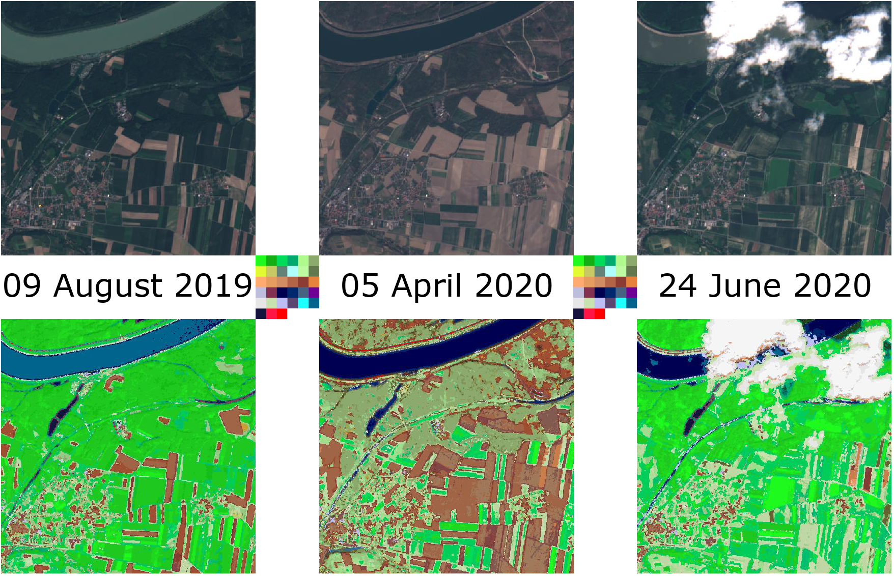
color33 transforms Sentinel-2 imagery into categories using a scientifically proven, near-real time expert system
You no longer need to begin only with reflectance values when developing an algorithm to extract information or learn from highly complex multispectral imagery. The color33 online processing service is based on a scientifically proven expert system that performs fully automated, near real-time, preliminary classification of multispectral pixels from multiple sensors. Unlike unsupervised clustering routines or machine learning approaches, color33 is based on a physical model, producing a set of spectral categories with known semantic associations.

Example use case: stratified analysis based on category
Task: EO analysts often require to calculate a normalized difference vegetation index (NDVI) across an entire image to later identify vegetation.
color33 solution: Instead of calculating an index based on reflectance values alone, color33‘s spectral categories enable only selecting observations relevant for the index. color33 enables users to select pixels that look like vegetation based on their spectral category before calculating NDVI, removing or minimizing the need for thresholding to extract meaningful information about vegetation. color33‘s spectral categories can be a powerful tool to stratify images for further analyses.
Check out the app here: https://app.color33.io/